
HIKING TRAILS
The Squaw Valley Creek Trail

From I-5, take Hwy. 89 to McCloud. Turn right (south) onto Squaw Valley Rd. Drive for 6.2 miles. Turn right onto gravel/dirt road signed Squaw Valley Creek. At 3.0 miles is parking near the bridge. Squaw Valley Creek Trail is a 7.1-mile loop that is a moderate hike. Enjoy a shorter hike by going in and out rather than completing the loop. The trail passes through a mature mixed conifer forest filled with wildflowers. It closely follows the creek, past waterfalls, and pools lined with umbrella plant (also called elephant ears). Poison oak is prevalent along the trail~USDF learn more...
McCloud River Falls
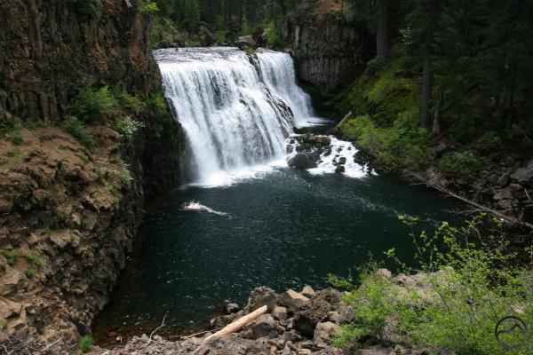
From I-5, take Hwy. 89 toward McCloud CA. 5.7 miles past McCloud, turn right onto McCloud River loop road, keep right, then you will find the parking lot near lower falls. Each of its significant points of interest is serviced by a paved road accessing an overlook above one of the three waterfalls. Picnic areas are also located near Upper and Lower Falls. Enjoy the trails, views, and swimming. Most begin the hike from the Lower Falls picnic area. learn more...
McCloud River Preserve
The McCloud River Preserve Trail offers a rare opportunity to enjoy the lower McCloud River. Between the Lake McCloud Dam and the stilled waters of Shasta Lake, the McCloud River flows wild and free through deep canyons cloaked in a primeval forest. Most of this stretch of the river is owned by private fishing clubs. There are two sections of the lower McCloud (below the Lake McCloud Dam) that are accessible to the public. learn more...
Mt. Shasta

The south and east sides of Mt. Shasta provides challenging cross country hiking and climbing opportunities for experienced mountaineers. Wilderness permits are required to enter the Mt. Shasta Wilderness and summit passes are also required if you plan to climb beyond the 10,000’ elevation. Check with the McCloud or Mt. Shasta Ranger Stations for more information. Brochures and maps of Mt. Shasta are available at the McCloud and Mt. Shasta Ranger Stations or from the Supervisor’s Office in Redding. A note about land ownership. A large portion of the land within the McCloud Area is privately owned. We suggest that you obtain a current National Forest map of the Shasta -Trinity to help you distinguish between public and private lands. We strongly encourage you to know where you are and to respect the rights of private property owners. ~USDF
For more information visit
Hiking The Pacific Crest Trail
About 60 miles of the Pacific Crest National Scenic Trail passes through the McCloud Area. Although there are no developed trailheads, good access points are located at Cabin Creek, Ah-Di-Na Campground, Ash Camp, Squaw Valley Creek, and Bartle Gap. The trail may be traversed by foot or on horseback; however, mountain bikes and motorized travel are prohibited. Brochures and maps of the Pacific Crest Trail are available at the McCloud Ranger Station or at the Supervisor’s Office in Redding.~USDF